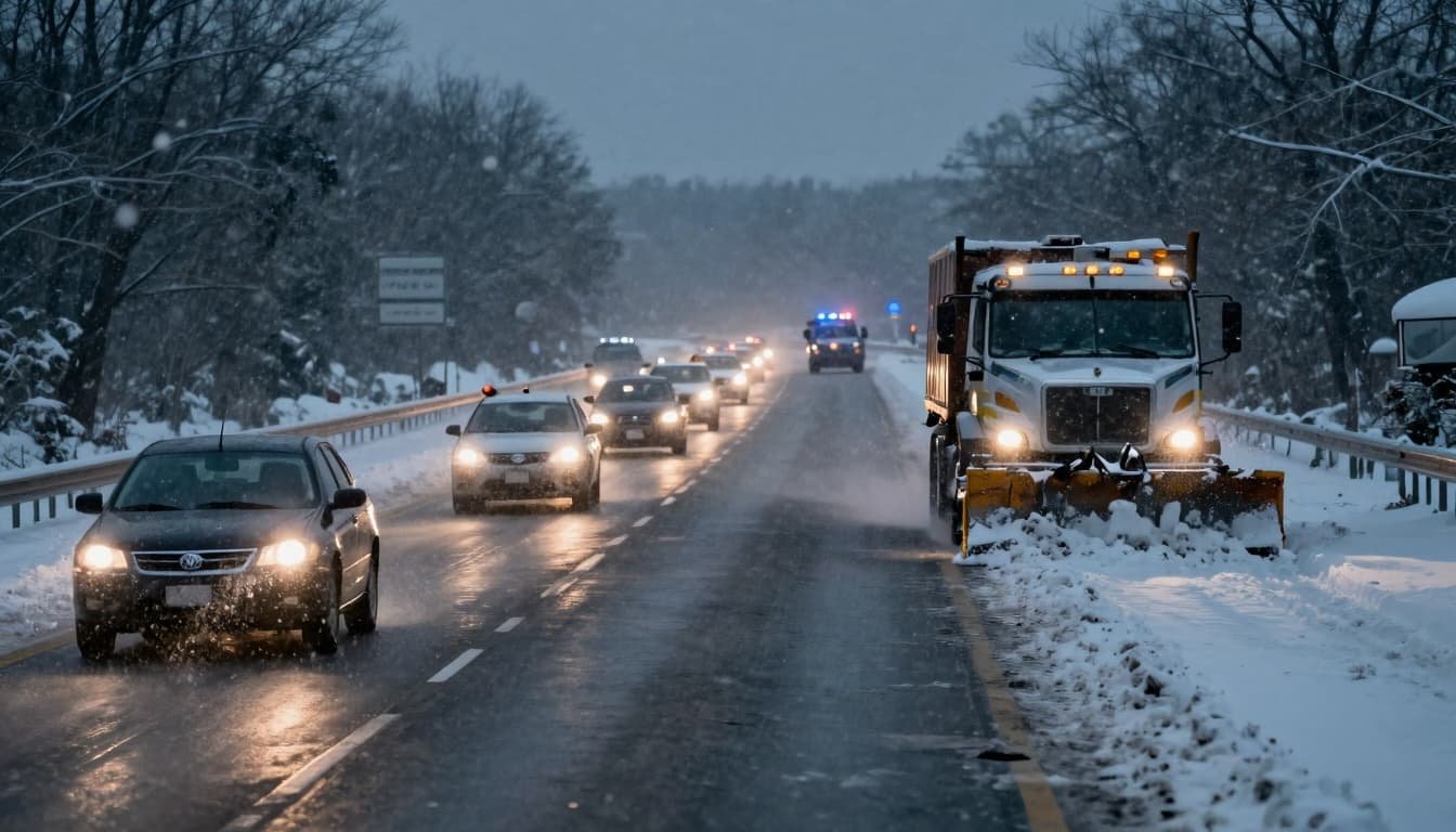
A winter storm forecast to deliver heavy snow, dangerous winds, and poor visibility is expected to affect parts of the United States from Tuesday through Friday, according to the National Weather Service (NWS). The system could disrupt Christmas travel for thousands of people, especially in areas facing winter storm warnings across California, Maine, and Alaska.
Forecasters say some locations could see more than 16 inches of snow, with gusts reaching extreme speeds in higher elevations. The NWS warns that travel may become “very difficult to impossible” in certain mountain corridors.
What we know about the winter storm and timing
The NWS outlook shows a multi-day event, with conditions worsening at different times depending on region. In general, the highest impacts are expected between Tuesday and Friday, right in the heart of holiday travel week.
While wintry weather is affecting many parts of the country, the heaviest snow and strongest winds highlighted in current warnings are focused on:
- California: significant mountain snow and high winds through the end of the week
- Maine: a snow event impacting commutes and holiday travel Tuesday into Wednesday
- Alaska: multiple areas under warnings for snow, reduced visibility, and gusty winds
Travelers should plan for rapidly changing road conditions, possible chain controls, flight delays, and intermittent closures in mountain passes.

California: Mountain snow, high winds, and dangerous passes
Several mountain regions of California are under winter storm warnings, with some areas facing multi-foot snowfall and damaging winds. The NWS expects the most dangerous conditions at higher elevations, where wind and blowing snow can reduce visibility quickly and create near whiteout conditions.
In the White and Inyo Mountains, the forecast calls for up to 16 inches of snow above 7,000 feet, and up to 2 feet above 8,000 feet, with winds near 50 mph from Tuesday afternoon through Friday afternoon. The NWS warns travel could be “very difficult to impossible,” including along Highway 168 through Westgard Pass.
Across the eastern Sierra slopes, winds around 55 mph are expected from Tuesday through Friday, with 6 to 10 inches of snow forecast above 6,000 feet.
Other hotspots include:
- Siskiyou County: up to 3 feet of snow in some areas, with winds up to 60 mph into Friday morning
- Modoc County: about 7 to 15 inches of snow with winds as high as 70 mph from early Wednesday into Friday (including Cedar Pass on Highway 299)
- Lassen, eastern Plumas, and eastern Sierra counties: up to 3 feet above 5,500 feet, with winds near 70 mph along higher ridges
- Mono County: up to 5 feet above 8,000 feet and winds up to 100 mph along the highest ridges, with heavy snow also impacting lower elevations along US-395
- Lake Tahoe region: 1 to 2 feet on lower ground, potentially up to 5 feet above 7,000 feet, plus very strong ridge winds
- Sierra Nevada south of Yosemite: projections include multiple feet of snow, with some totals reaching 7 to 8 feet in the hardest-hit areas outside Yosemite Valley
In mountain storm setups like this, the risk is not only snow totals. High winds can create drifting snow, sudden visibility drops, and hazardous driving even when totals are not extreme.
Maine: Snow expected to impact commutes and holiday travel
In the Northeast, the NWS warns that parts of south central and southwest Maine could see 6 to 12 inches of snow from Tuesday into Wednesday afternoon.
Forecasters specifically caution that hazardous conditions could impact the Tuesday evening and Wednesday morning commutes, as well as broader holiday travel. For drivers, that often means slick secondary roads, reduced visibility at times, and increased crash risk during peak travel hours.

Alaska: Reduced visibility and heavy snow in multiple regions
In Alaska, the NWS warns of snow, wind, and reduced visibility for a range of locations. The Baldwin Peninsula, Kivalina, lower Kobuk Valley, Noatak Valley, and surrounding areas could see up to 6 inches of snow (especially above 1,500 feet) through Wednesday morning, with gusts up to 35 mph. Visibility could drop to less than half a mile at times.
The Fairbanks North Star Borough and the central Interior may receive up to 10 inches of snow. The western Alaska Range is forecast to see up to 14 inches from Tuesday through Thursday morning.
When wind and snow combine, travel risks increase quickly. Even moderate snow totals can become serious when blowing snow reduces visibility and drifts cover road markings.
Travel advice from the National Weather Service
The NWS urges travelers to prepare for winter conditions and consider delaying trips if weather becomes too dangerous. The agency recommends keeping emergency supplies in your vehicle.
The NWS advises: “If you must travel, keep an extra flashlight, food, and water in your vehicle in case of an emergency.” It also notes that travelers can call 1-800-427-7623 for road information.

Practical checklist for holiday travelers
If you are traveling during the storm window, a few basic steps can reduce risk:
- Check the forecast right before you leave (conditions can change quickly).
- Plan your route and look for mountain pass alerts or closure updates.
- Build extra time into your schedule for slower driving and stops.
- Pack emergency supplies: water, snacks, blankets, flashlight, phone charger.
- Keep your gas tank above half in case you get delayed.
- For mountain areas: carry chains if required and know how to use them.
- For flights: check airline alerts early and consider backup options.
What happens next
The storm is expected to continue through the week in many impacted regions, with the most severe effects tied to mountain elevations and wind-prone locations. Travelers should continue monitoring local NWS updates and consider delaying trips if warnings expand or conditions deteriorate.
To contact us click Here .