First Alert Weather Day in the Tri-State area with flooding, strong winds, and big temperature swings expected.
A strong storm system is moving into New York City, Long Island, and coastal New Jersey, bringing heavy rain, strong winds, and coastal flooding. Forecasters have issued coastal flood advisories and declared Friday a First Alert Weather Day for the region.
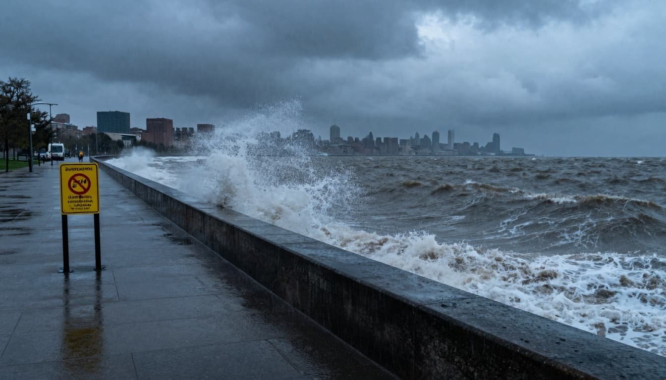
The main threats will be heavy rain, gusty winds of 45 to 50 miles per hour or higher, and minor coastal flooding in low-lying areas. The combination of high tides and strong onshore winds will push water into vulnerable shorelines and bays.
Residents across the Tri-State area are urged to stay alert, plan for a slower commute, and secure any loose outdoor items before the worst of the weather arrives.
Where the Coastal Flood Advisory Is in Effect
The National Weather Service has issued coastal flood advisories for several parts of the New York City metro area and New Jersey. The advisories mainly focus on areas along the coast, bays, and tidal rivers.
In New York, coastal flood advisories are in effect for:
- Parts of Manhattan
- Brooklyn and Queens
- Staten Island
- The south shore of Long Island
In New Jersey, the advisories include vulnerable coastal and bayfront locations in northern counties such as Hudson, Essex, and Union. These areas are at greater risk when strong onshore winds and high tides line up at the same time.
Forecasters say up to one foot of coastal inundation is possible in the most exposed areas of Long Island and Queens. Closer to the city and northern New Jersey, water levels could reach up to half a foot above normal, enough to flood some low spots.
What Kind of Flooding to Expect
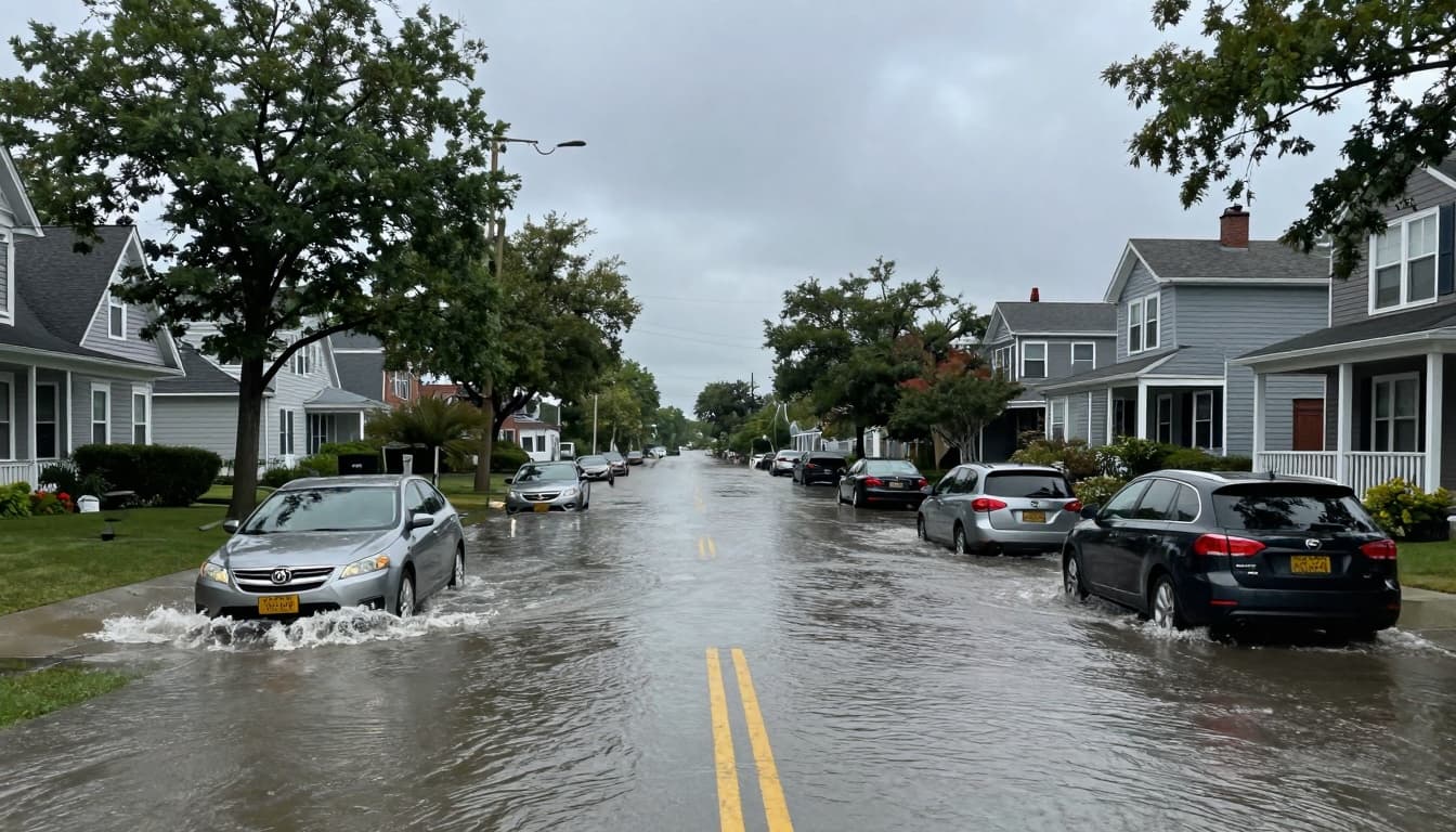
This event is expected to produce mainly minor coastal flooding, but it can still cause problems for travel and property. Even shallow water can make some roads dangerous or impassable.
Officials warn that the following areas may see issues:
- Low-lying coastal roads and streets near bays and inlets
- Parking lots close to the water
- Parks and walkways along the shoreline
- Basements in flood-prone neighborhoods
Drivers are urged to leave extra time for the Friday morning commute. If you see water on the road, do not try to drive through it. Even a few inches of moving water can cause you to lose control of your vehicle.
Flooded roads may also hide deep potholes, debris, or washed-out sections. Follow detours, obey barricades, and turn around when you see water covering the street.

Strong Winds and Power Outage Risk
Along with the coastal flooding threat, the storm will bring strong, gusty winds across the entire region. A wind advisory is in effect, with gusts of 45 to 50 miles per hour or more possible.
These strong winds may:
- Knock down tree branches or, in some cases, entire trees
- Bring down power lines and cause scattered outages
- Blow around unsecured holiday decorations and lawn items
- Make travel on bridges and elevated roadways more difficult
If you have holiday inflatables, light displays, or loose outdoor furniture, it is a good idea to secure them or bring them inside. This can prevent damage and keep items from becoming flying debris in the wind.
Unusually Warm, Then a Sharp Temperature Drop
One of the strangest parts of this storm will be the temperature swings. Friday morning will start off unusually warm for December, with readings climbing into the 50s and even the low 60s in some spots.
Record-high temperatures are possible during the morning commute. It may feel more like a rainy spring day than a winter morning.
However, this warm air will not last. Behind the storm, a surge of colder air will move in quickly by late afternoon and evening. Wind chills will tumble into the 30s, 20s, and even the teens overnight.
This means you might leave the house in a light jacket but need a heavier coat by the time you head home. Plan your clothing with the big temperature drop in mind.
Timeline: What to Expect
Here is a simple breakdown of the forecast for the next few days:
- Thursday: Mild, with highs near 50 degrees.
- Thursday night: Rain and wind ramp up overnight as the storm approaches.
- Friday morning: Heavy rain and gusty winds at their worst; locally damaging wind gusts possible; coastal flooding near high tide.
- Friday afternoon and evening: Rain begins to move out; winds stay blustery as colder air rushes in.
- Saturday: Chilly and breezy, with highs only in the upper 30s.
- Sunday: Temperatures rebound closer to normal, with highs in the mid-40s.
The worst travel conditions will likely occur during the Friday morning commute when heavy rain, ponding on roads, and gusty winds all come together. If possible, allow extra time, use public transit, or shift travel to later in the day.
How to Prepare for the Storm
Even though this storm is expected to bring mostly minor flooding, it can still cause headaches if you are not ready. A few simple steps can help you stay safe and reduce damage.
- Move your car from low-lying streets or spots that often flood during heavy rain.
- Clear leaves and debris from storm drains and gutters if it is safe to do so.
- Charge phones and devices in case of isolated power outages.
- Secure or bring inside lightweight decorations, trash cans, and patio furniture.
- Have a flashlight ready and know how to report power outages to your local utility.
If you live near the coast or a tidal river, stay updated with local alerts from the National Weather Service, local TV stations, or weather apps. Conditions can change quickly around high tide, especially with strong onshore winds.
Staying Safe During Coastal Flooding
Coastal flooding can be dangerous, even when it is described as “minor.” Fast-moving water can knock you off your feet, and driving through flooded streets is never safe.
During the advisory:
- Avoid walking or driving through floodwaters.
- Stay away from seawalls and jetties where waves may crash over the top.
- Keep children and pets back from the water’s edge.
- Follow any local road closures and instructions from emergency managers.
After water recedes, be careful around sand and debris left on roads and sidewalks. Some areas may stay slick or muddy for several hours.
This article is based on the latest information from the National Weather Service and local First Alert Weather forecasts at the time of writing. Forecasts can change, so always check for updated alerts before traveling.
To contact us click Here .